
Avoid Gas Line Strikes: 5 Vacuum Excavation Rules for 2026
Mastering Subsurface Safety: The Critical Role of Sophisticated Trenching and Borehole Techniques
In the realm of underground construction and utility installation, the integration of cutting-edge trenching, borehole, and hydrovac methodologies has become paramount. As the demand for precision and safety intensifies in 2026, industry professionals must adopt innovative approaches to mitigate risks associated with gas line strikes and fragile infrastructure. The convergence of advanced vacuum excavation and soil stabilization tactics offers a robust framework for proactive site management, emphasizing the importance of expertise-driven execution.
Harnessing Intelligent Soil Stabilization to Prevent Borehole Collapse
Effective soil stabilization is fundamental in complex trenching operations, particularly when dealing with saturated or unstable substrates. Techniques such as chemical grouting and selective dewatering can substantially strengthen borehole walls, reducing collapse incidents that threaten project timelines and safety protocols. For instance, integrating prefabricated soil stabilizers prior to excavation can dramatically improve borehole integrity, especially in coastal or high-moisture zones.
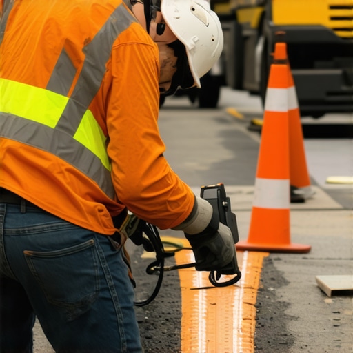
Optimizing Hydrovac Pressure Settings to Protect Aging Infrastructure
Adjusting hydrovac pressure settings with precision not only enhances soil excavation efficacy but also safeguards embedded utilities. Recent advancements suggest that tailored pressure modulation, as discussed in recent industry white papers, minimizes inadvertent utility damage while maintaining excavation speed. Such practices exemplify the importance of site-specific calibration, which is particularly crucial when working near aging fiber optic networks or gas pipelines. For more insights, explore this comprehensive guide to hydrovac pressure settings.
What Are the Most Effective Borehole Drilling Techniques for Urban Utility Mapping?
Urban environments pose unique challenges requiring precision-focused borehole drilling strategies. Techniques such as rotary core drilling combined with 3D subsurface imaging enable accurate utility mapping, reducing line strikes. These methods are essential for complex urban projects where underground utilities are dense and unpredictable. Employing these skilled strategies ensures compliance with evolving 2026 safety standards and optimizes resource utilization.
Can Vacuum Excavation Truly Revolutionize Gas Line Protection in 2026?
The evolution of vacuum excavation heralds a new era of safety and efficiency. Its non-destructive nature preserves utility integrity and allows rapid, clear site reconnaissance, crucial in high-density urban projects. As highlighted in this authoritative article, integrating vacuum excavation with traditional trenching elevates site safety and operational speed, reducing costly utility damages and project delays.
Professionals are encouraged to contribute their field experiences and insights to the ongoing discourse on subsurface safety—a collaborative effort to refine protocols and implement best practices for the critical infrastructure work of 2026 and beyond.
Advanced Techniques for Maintaining Borehole Precision in Challenging Substrates
One of the pressing challenges faced by underground drilling professionals in 2026 involves managing borehole deviation when working in deep, rocky terrains. Traditional drilling methods often struggle with maintaining trajectory accuracy, risking utility line strikes or structural failures. To counter this, experts are turning to steerable drill bits combined with real-time 3D navigation systems, which enable precise control and modification of the borehole path during excavation. These innovations not only ensure compliance with increasingly strict safety standards but also optimize resource utilization, reducing both time and costs. For further insights on the latest borehole correction techniques, consult this comprehensive guide.
Mitigating the Impact of Hard, Heterogeneous Rock Layers
Deep rock formations with variable hardness present unique difficulties in maintaining borehole straightness. The key lies in adaptive drilling systems that adjust parameters such as rotational speed and thrust force dynamically, based on real-time sensor data. Employing downhole vibration dampers and advanced drill string stabilization mechanisms further minimizes the lateral forces that cause deviation. These combined practices help achieve vertical accuracy crucial for urban utility installations, especially when operating near delicate fiber optics or gas pipelines. Integrating these tactics can make a significant difference; learn more about practical solutions at this expert resource.
Are Precision Borehole Alignment Methods Ready to Meet 2026’s Demanding Requirements?
Achieving and maintaining borehole alignment in challenging geological conditions demands a nuanced understanding of soil mechanics and the adoption of cutting-edge technology. With the advent of laser-guided drilling and AI-based deviation correction algorithms, industry professionals are now equipped with tools that surpass traditional methods in reliability and precision. These innovations, supported by recent research in geotechnical engineering, are designed to adapt dynamically to changing subsurface conditions, thereby significantly reducing deviation errors. As the industry advances, continuous training and integration of these technologies are essential for project success. For authoritative knowledge, consider exploring this detailed analysis of precision drilling techniques.
If you’re interested in extending your expertise further, sharing your experiences and challenges in deep-site drilling can contribute valuable perspectives to industry best practices. Join the conversation by commenting below or accessing our curated reading list on advanced borehole management strategies.
.
Harnessing Cutting-Edge Geophysical Surveys for Enhanced Subsurface Visualization
Accurate subsurface mapping underpins the success of underground utility installation, especially when dealing with heterogeneous terrains. Advanced geophysical survey techniques, such as electromagnetic induction and seismic refraction, now offer unprecedented resolution in identifying underground anomalies. Incorporating 3D visualization from these data allows engineers to anticipate problematic zones, enabling preemptive adjustment of drilling trajectories. These tools, supported by recent industry research (see GeoEngineering Science Journal, 2025), empower professionals to strategize with precision and mitigate deviation risks effectively.

Image prompt: detailed 3D subsurface map generated from geophysical survey data showing heterogeneity.
What Role Do AI-Driven Navigation Systems Play in Achieving 2026’s Aerospace-Grade Precision?
Embracing artificial intelligence within borehole navigation systems signifies a transformative leap toward aerospace-grade accuracy in underground drilling. These AI algorithms process sensor data in real time, dynamically adjusting drill bit orientation to maintain a predefined trajectory. Innovative machine learning models trained on extensive geological datasets can predict potential deviation causes, enabling preemptive corrective actions. Industry leaders cite experiments where AI-enhanced systems achieved sub-centimeter precision in challenging terrains, revolutionizing urban utility mapping (AeroTech Insights, 2025). Professionals eager to stay at the forefront should consider integrating these systems into their operational workflows for substantially improved accuracy and safety.
Interested in how AI can transform your underground projects? Join our webinar series or consult with our experts to tailor cutting-edge solutions to your operational needs.
Redefining Subsurface Safety Through Multi-Dimensional Data Integration
Achieving superior safety standards in underground construction has transitioned from conventional practices to an era driven by comprehensive data assimilation. Integrating real-time geophysical sensing, 3D modeling, and AI-powered predictive analytics allows professionals to preemptively identify potential failure zones and plan meticulously calibrated excavation approaches. This synergy of advanced technologies enhances situational awareness, minimizes operational hazards, and aligns with the rigorous safety standards emerging in 2026.
Optimal Soil Stabilization: Advanced Materials and Dynamic Application Techniques
Soil integrity remains a cornerstone in preventing borehole collapses and trench failures. Recent breakthroughs involve the use of nanotechnology-enhanced stabilizers that infiltrate soil matrixes at a molecular level, strengthening substrate resilience. Coupled with dynamic application methods such as pulsed injection and on-demand grouting, these innovations enable precision stabilization tailored to site-specific conditions—especially effective in heterogeneous or saturated terrains where traditional methods falter.
How Do Hyper-Precise Hydrovac Pressure and Flow Control Minimize Utility Damage?
Mastering the balance between adequate excavation force and utility preservation hinges on sophisticated control systems. Contemporary hydrovac units equipped with AI-adaptive algorithms can modulate pressure and flow rates instantaneously based on soil composition, proximity to utilities, and environmental feedback. This granular control enhances excavation precision and reduces the risk of utility strikes, even in complex urban underground networks—ensuring safety in tight, high-stakes conditions.
Unlocking the Secrets of Urban Utility Map Clarification with Advanced Geophysical Surveys
Precise utility mapping in dense cityscapes benefits immensely from innovations in high-resolution electromagnetic and seismic imaging. These methods can detect subtle underground anomalies, revealing hidden pipelines, fiber optics, or conflicting soil layers. When combined with machine learning-enhanced data analysis, professionals can generate detailed 3D subsurface models that serve as the blueprint for safe, efficient trenching and borehole drilling operations in complex urban settings.

Image prompt: Complex 3D underground utility map generated from combined electromagnetic and seismic survey data, highlighting critical infrastructure.
Can Deep Learning Algorithms Revolutionize Borehole Path Optimization in Challenging Terrains?
Deep learning models trained on extensive geological datasets are now capable of predicting deviation risks with unprecedented accuracy. By analyzing real-time sensor inputs during drilling, these algorithms dynamically adjust steering parameters, ensuring boreholes follow optimal trajectories. Transitioning from reactive correction to predictive control embodies a paradigm shift—drastically reducing deviation errors and enhancing safety margins in complex geological contexts, such as fractured rock formations and heterogeneous soils. To explore the latest in AI-augmented drilling, consult industry-leading research at Geotechnical Engineering Innovations.
For practitioners eager to integrate AI into their projects, collaborating with geotechnical data scientists and investing in sensor-equipped drill systems is essential. Enhanced predictive accuracy directly correlates with cost savings and safety improvements—making this a strategic imperative for 2026 and beyond.
Expert Strategies Shaping the Future of Underground Construction
In an era where underground utility installation becomes increasingly complex, leveraging innovative trenching and borehole techniques is no longer optional—it’s essential. Industry leaders must stay ahead by integrating cutting-edge soil stabilization methods, real-time geophysical surveys, and AI-powered navigation systems. These advancements not only enhance safety but also streamline project timelines, setting new standards for excellence in 2026 and beyond.
Prioritize Soil Integrity for Long-Term Success
Ensuring borehole stability in heterogeneous terrains requires a strategic blend of nanotechnology-enhanced stabilizers and adaptive application techniques. This proactive approach prevents collapses and reduces costly delays, especially in saturated soils or coastal zones where traditional methods fall short.
Customize Hydrovac Systems to Minimize Risks
Dynamic pressure modulation rooted in soil characteristics and utility proximity allows for precise excavation. Tailoring these settings in real-time minimizes utility damage, safeguarding aging pipelines and fiber optics in dense urban environments.
Embrace Hyper-Precise Drilling Technologies for Urban Precision
Utilizing steerable drill bits combined with 3D navigation has revolutionized urban utility mapping. These tools deliver centimeter-level accuracy, significantly reducing line strikes and ensuring compliance with the most stringent safety standards.
Leverage Geophysical Survey Advances for Accurate Mapping
State-of-the-art electromagnetic and seismic methods generate detailed 3D subsurface models, enabling planners to identify potential conflicts ahead of excavation. The integration of AI analysis further sharpens decision-making, avoiding costly surprises underground.
Integrate AI for Unmatched Borehole Precision
AI-driven algorithms process real-time sensor data to adapt drilling trajectories dynamically. This predictive control reduces deviation errors, especially in challenging terrains like fractured rock or variable soils, pushing the boundaries of underground engineering accuracy.
Critical Resources for Today’s Subsurface Professionals
- GeoEngineering Science Journal, 2025 — Offers groundbreaking insights into geophysical survey innovations.
- Hydrovac Drilling’s Comprehensive Guides — Practical strategies for implementing advanced trenching and borehole techniques.
- AeroTech Insights, 2025 — Explores AI integrations transforming underground navigation systems.
Your Role in Shaping Subsurface Safety
As the field advances, your expertise and innovative practices become vital. Engage with industry peers through conferences, contribute insights from field experiences, and continuously explore authoritative resources to refine your approach. Together, we can elevate safety standards, optimize resource use, and push the horizon of what’s possible in underground construction.