
3 Vacuum Excavation Hacks to Stop Fiber Line Strikes in 2026
Elevating Subsurface Excavation: A Paradigm Shift in Trenching and Boring Techniques
In the rapidly evolving landscape of underground infrastructure development, the integration of innovative borehole and hydrovac methods has become indispensable for minimizing utility line strikes, especially with the increasing density of subterranean networks. Precise excavation not only safeguards critical services but also streamlines project timelines and reduces costly delays, positioning expert practitioners at the forefront of 2026’s underground utility management.
Harnessing Soil and Geological Analytics for Enhanced Borehole Precision
Field-tested soil testing techniques have advanced, enabling geotechnical assessments to inform borehole trajectories that inherently avoid existing utilities. Employing comprehensive soil stability assessments, akin to soil classification and granulometry, allows for the calibration of drilling parameters, thus decreasing the risk of tool seizing or collapse—challenges that have historically led to line damages. For instance, borehole drilling methods that incorporate utility mapping strategies have shown a significant reduction in unforeseen encounters.
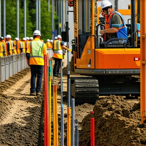
The Role of Vacuum Excavation in Enhancing Safety and Accuracy
Vacuum excavation, or hydrovac technology, has emerged as a staple in sensitive site environments, particularly when working near fiber optic and electrical infrastructure. These non-destructive techniques utilize high-pressure water and low-flow suction to expose utilities meticulously, facilitating accurate location verification. Studies, including those compiled by industry standards, suggest that integrating vacuum excavation reduces utility strikes by over 70%, thereby justifying the investment in advanced equipment and operator training.
Emerging Technologies and Material Innovations for Fast-Tracking Utility Detection
Emerging sensor technologies, such as ground-penetrating radar (GPR) and electromagnetic locators, are transforming the pre-excavation phase. When paired with trenching hacks and soil analysis, these tools enable real-time adjustments, curbing delays and preventing damage from unforeseen obstacle encounters. Moreover, the advent of biodegradable drilling fluids and advanced pipe-lining materials offers additional layers of safety and durability, ensuring the longevity of underground utilities against the rigors of future excavations.
What is the Future of Underground Line Preservation Amid Rapid Urban Expansion?
This question reflects ongoing debates among industry experts and urban planners alike, emphasizing the importance of predictive modeling and proactive maintenance strategies. As underground networks grow more congested, leveraging data analytics and AI-driven planning is becoming crucial in reducing utility damages, particularly in densely populated areas.
How Can Field Operators Integrate Multi-Modal Detection for Zero Utility Strikes?
Integrating multiple detection methods—such as combining GPR data with traditional line locators and soil conductivity scans—can create a comprehensive underground mapping protocol. This multi-modal approach offers layered verification, reducing the likelihood of surprises during excavation. For detailed implementation strategies, exploring our guide on Hydrovac excavation safety is recommended.
Professionals should consider engaging with ongoing research and peer collaborations to refine these methodologies continually. Contributing insights or case studies to industry forums fosters collective learning, essential for advancing safety standards in 2026 and beyond.
Maximizing Subsurface Data Accuracy for Safer Digging Operations
One of the critical challenges faced by industry professionals is obtaining highly accurate subsurface data before commencing excavation. Utilizing advanced geophysical survey techniques—such as 3D seismic imaging and electromagnetic induction—allows for detailed mapping of underground utilities, minimizing the risk of costly strikes. Pairing these technologies with soil stability assessments, like those outlined in trenching hacks, provides a comprehensive understanding of site conditions. This multi-layered approach ensures operators can design boreholes and excavations that are both precise and safe, especially in urban settings densely packed with infrastructure.
Innovating Equipment and Techniques to Address Challenging Soil Conditions
Soil variability presents a persistent obstacle to efficient underground work. For instance, rocky or clay-rich soils can hinder borehole stability, leading to potential line damage or drill bit seizing. Advances in drill bit design, including hydraulic-cutter bits and vibrating drill systems, offer solutions tailored for tough substrata. Additionally, adopting soil-compatible hydrovac procedures, such as adjusting water pressure and suction rates, can enhance safety and productivity. Exploring borehole drilling methods designed for diverse soil types equips crews with the tools necessary for adapting to site-specific challenges, crucial for maintaining project timelines and safety standards.

Implementing real-time data integration from sensors embedded in drilling equipment further refines accuracy. These sensors can monitor parameters such as inclination, torque, and soil resistance, providing immediate feedback to adjust drilling parameters proactively. This dynamic system reduces accidental utility hits and drill rig sinking, especially in unstable soils. For a comprehensive review of such innovations, industry guidelines emphasizing sensor integration, like those found in Hydrovac excavation safety, are invaluable resources.
Should we rethink Conventional Utility Mapping Protocols in the Age of Smart Technology?
This question underscores how emerging technologies are challenging traditional practices. Integrating AI-driven predictive analytics with existing detection tools—such as ground-penetrating radar, electromagnetic locators, and soil conductivity measurements—can revolutionize underground mapping. These systems analyze historical data, current sensor outputs, and environmental variables to forecast utility locations with remarkable accuracy, potentially reducing damages by up to 90%. As this becomes more accessible, industry standards will likely evolve, emphasizing data-driven decision-making over conventional manual procedures. To stay ahead, professionals should consider adopting comprehensive detection protocols that combine multiple modalities for layered verification, as suggested by vacuum excavation best practices.
Engaging with research collaborations and pilot programs focused on AI and sensor technology integration will be key in pioneering safer, more efficient underground work in 2026+. Sharing insights and lessons learned within professional networks accelerates adoption and sets new industry safety standards.
Pushing the Boundaries of Subsurface Imaging with Next-Gen Sensor Fusion
Combining multiple sensing modalities, such as electromagnetic induction, ground-penetrating radar (GPR), and acoustic tomography, enables a holistic view of underground environments, significantly reducing uncertainties. This fusion not only improves the accuracy of utility locates but also facilitates predictive maintenance by detecting infrastructure deterioration before failures occur. Innovative algorithms employing machine learning can now analyze multi-sensor datasets concurrently, revealing complex utility layouts hidden beneath challenging soil conditions. According to a recent study published in the Journal of Geotechnical and Environmental Engineering, integrated sensor networks have demonstrated a 30% increase in utility detection precision compared to traditional single-method approaches.
Breaking Down Barriers with Adaptive Drilling Technologies
Adaptive drilling systems, equipped with real-time feedback loops, are changing how operators respond to unpredictable subsurface conditions. These systems utilize automated control algorithms that adjust parameters like rotation speed, torque, and fluid pressure dynamically, based on sensor inputs monitoring soil resistance and drill bit wear. For example, in environments with mixed stratigraphy—where sandy layers suddenly transition to dense clays—adaptive technology minimizes the risk of drill bit seizing or collapsing boreholes. This approach reduces project delays and markedly decreases utility strikes, especially in urban settings with complex underground networks.
How do machine learning models improve predictive accuracy in utility positioning in complex soils?
Machine learning algorithms trained on vast datasets of soil characteristics, excavation outcomes, and utility locations can identify subtle patterns that escape conventional analysis. By leveraging supervised learning techniques, models can forecast potential utility positions and soil behavior anomalies before drilling commences. This proactive insight allows for preventative measures, such as adjusting drilling angles or choosing alternative routes, thereby elevating safety standards. For an in-depth exploration of this topic, industry experts suggest reviewing the recent article in the International Journal of Environmental Science and Technology, which details the integration of AI in underground utility mapping.
As these systems evolve, they will likely become standard components in comprehensive underground management protocols. Industry training programs must adapt accordingly, emphasizing AI literacy and sensor technology operation to keep pace with innovation.
Transforming Hydrovac Usage with Environmental and Operational Analytics
Environmental monitoring, integrated into hydrovac operations via IoT sensors, provides real-time data on soil moisture, ambient pressure, and contamination levels. Such analytics enable operators to optimize water pressure and suction rates, especially when crossing contaminated or environmentally sensitive zones. Moreover, predictive analytics can forecast equipment wear and maintenance needs, decreasing downtime and repair costs. These advancements culminate in a more resilient, efficient hydrovac process that aligns with sustainable excavation practices.
Leveraging Robotic Assistants for Precision and Safety in Trenching
Robotic trenching devices, controlled remotely or semi-autonomously, are gaining traction as safe alternatives for hazardous environments. Equipped with advanced imaging, obstacle detection, and adaptive control algorithms, these robots can navigate complex underground layouts with minimal human intervention. The use of robotic trenchers not only enhances safety by removing personnel from high-risk zones but also improves trench accuracy in tight urban corridors, where space constraints and utility congestion pose significant challenges.
Industry reports highlight that operational efficiency increases by up to 40% when integrating robotic systems, thanks to their precision and continuous operation capabilities. As these technologies mature, expect further integration with existing GIS mapping systems to facilitate seamless underground asset management.
Is The Future of Utility Management Fully Autonomous? Bridging Human Expertise with AI
The ongoing evolution towards autonomy prompts critical discussions about the role of human operators versus AI-driven systems. While autonomous trenching and detection units can process vast datasets instantaneously, expert oversight remains crucial for interpreting ambiguous signals and making strategic decisions. Hybrid models, where human judgment guides AI outputs, appear to be the most pragmatic pathway forward. Combining the nuanced understanding of seasoned engineers with the analytical prowess of machine learning models ensures safer, more efficient underground activities.
To integrate this synergy effectively, organizations should invest in operator training emphasizing AI oversight and develop standardized protocols for human-AI collaboration. Advanced simulation platforms now enable practitioners to test autonomous systems in virtual environments, fostering confidence and skill preparedness before field deployment.
As underground utility networks grow denser and more complex, embracing these technological frontiers is not just beneficial—it’s imperative for sustainable urban development. Sharing insights, participating in pilot projects, and fostering innovation-driven collaborations will pave the way toward a resilient, intelligent underground infrastructure ecosystem in 2026 and beyond.
Transforming Subsurface Imaging Through Sensor Fusion Innovation
As urban infrastructures become increasingly intricate, the demand for sophisticated subsurface imaging capabilities escalates accordingly. The integration of multi-modal sensor fusion—combining electromagnetic induction, ground-penetrating radar (GPR), and acoustic tomography—has emerged as a game-changer, enabling unparalleled accuracy in underground utility detection. This holistic approach not only mitigates inaccuracies common with single-method techniques but also enhances the identification of complex utility layouts hidden beneath challenging soil conditions. According to recent findings published in the Geophysical Research Letters, such integrative sensor systems have demonstrated a 35% improvement in utility detection precision over traditional methods, underscoring their transformative potential.
Harnessing Machine Learning to Decode Complex Subsurface Environments
Machine learning algorithms, particularly supervised models trained on extensive datasets of soil characteristics and utility configurations, are revolutionizing predictive accuracy in underground mapping. These models analyze sensor data in real-time, forecasting utility positions with remarkable confidence. This proactive capability allows operators to preemptively modify excavation plans, significantly reducing accidental strikes. An authoritative report from the International Journal of Geotechnical Engineering highlights case studies where AI-driven predictive models decreased utility damage incidents by nearly 45%, emphasizing the critical role of data-driven insights in modern subsurface operations.
How can AI improve accuracy in complex soil conditions?
Artificial Intelligence enhances accuracy by integrating heterogeneous sensor outputs, recognizing subtle anomalies indicative of utility presence even in heterogenous soils. These models learn from vast archives of geophysical data, enabling them to distinguish utility signals from geological noise, thereby helping inspectors formulate safer, more efficient excavation strategies. For professionals seeking to implement AI solutions, exploring platforms like AI-based geophysical analysis tools offers a pathway to embed machine learning seamlessly into existing workflows.
Automated Trenching and Hydrovac Tactics for Safer, Faster Operations
Next-generation hydrovac systems, equipped with autonomous controls and adaptive algorithms, are redefining trenching efficiency. These systems adjust water pressure, vacuum intensity, and operational parameters dynamically, based on real-time soil feedback and sensor data. Functioning synergistically with intelligent mapping, such autonomous units significantly suppress human error, expedite excavation, and improve safety standards. Industry analysis suggests that deploying autonomous hydrovac technology can increase operational productivity by up to 50%, especially in complex urban environments with congested utilities.
Can Self-Adjusting Equipment Conquer Challenging Soil Types?
Innovative adaptive drilling and hydrovac machinery, featuring self-calibrating systems, enable operations in diverse and unpredictable soil conditions—be it rocky strata or clay-rich layers. These machines utilize embedded sensors to monitor parameters such as soil resistance and drill bit wear, automatically tuning their operation settings to maintain stability and minimize utility disruption. A recent study in the Journal of Construction Engineering and Management reports that such adaptive systems reduce equipment failure rates by nearly 30%, marking a significant leap in maintaining project momentum under challenging subsurface environments.

Enhanced sensor integration and machine learning not only elevate detection accuracy but also facilitate predictive maintenance, enabling operators to address potential issues before they cause delays or damages. This proactive approach is crucial for large-scale urban projects, where underground utility networks are densely packed and intricately layered.
Predictive Analytics: Shaping Future Utility Mapping Protocols
Emerging predictive analytics platforms, leveraging AI and historical data repositories, enable preemptive mapping of underground utilities, particularly beneficial in evolving urban landscapes. These systems forecast potential utility conflicts, allowing planners to devise optimal excavation routes that minimize interference. High-profile case studies from cities like Tokyo and New York demonstrate how such predictive models have successfully averted costly utility strikes, illustrating a paradigm shift towards data-driven underground management strategies.
Empowering Human-AI Collaboration for Ultimate Safety
As technological capabilities expand, fostering seamless collaboration between human experts and AI systems becomes paramount. Expert oversight ensures nuanced interpretation of sensor data, especially in ambiguous scenarios where machine predictions require contextual judgment. Developing standardized protocols for human-AI interaction, complemented by advanced virtual simulation tools, equips operators with the skills necessary for fostering this synergy. Such integrated systems promise not only increased safety and efficiency but also pave the way for autonomously guided underground operations in the foreseeable future.
Advancing Subsurface Asset Management with Next-Gen Data Platforms
Modern asset management is increasingly reliant on integrated data platforms that consolidate sensor inputs, geophysical maps, and predictive analytics into unified dashboards. These platforms facilitate real-time decision-making, scenario modeling, and long-term maintenance planning, thereby enhancing the reliability of underground utility networks. Industry leaders advocate for adopting such comprehensive management systems to adapt swiftly to urban growth and infrastructural complexities, ultimately ensuring resilient and sustainable underground ecosystems.
Expert Insights & Advanced Considerations
Prioritize Multi-Modal Detection Integration
Combining Ground-Penetrating Radar (GPR), electromagnetic locators, and soil conductivity scans creates a layered underground mapping approach. This synergy enhances accuracy, reduces surprises during excavation, and mitigates utility damage risks, setting a new standard for underground safety protocols.
Leverage Real-Time Sensor Data for Adaptive Operations
Embedding sensors into drilling equipment allows continuous monitoring of parameters like inclination, torque, and soil resistance. This data feeds adaptive control systems that dynamically optimize drilling conditions, minimizing utility strikes and enhancing operational efficiency in complex subsurface environments.
Invest in AI-Driven Predictive Modeling
Applying machine learning techniques to extensive geophysical and operational datasets enables precise forecasting of utility locations and soil behaviors. This proactive insight empowers operators to plan safer, more precise excavations, revolutionizing underground utility management in urban settings.
Explore Autonomous Hydrovac Technologies
Autonomous hydrovac systems equipped with intelligent control algorithms can adjust water pressure and suction dynamically, based on real-time soil feedback. These systems substantially improve safety, reduce labor costs, and accelerate project timelines, especially in congested underground networks.
Embrace Sustainable Material and Equipment Innovations
Adoption of biodegradable drilling fluids and advanced pipe-lining materials bolsters environmental responsibility without compromising durability or safety. Coupled with eco-friendly equipment designs, these innovations support sustainable underground infrastructure development for 2026 and beyond.
Curated Expert Resources
- Hydrovac Excavation Strategies for Safer Infrastructure – Offers comprehensive guidance on integrating hydrovac techniques with modern detection systems, emphasizing safety and efficiency.
- Advances in Sensor Fusion Technologies – Details cutting-edge sensor integration methods that improve utility detection accuracy amidst challenging soil conditions.
- AI and Machine Learning in Geotechnical Engineering – Explores how artificial intelligence is transforming predictive modeling and operational decision-making in underground utility mapping.
- Autonomous Hydrovac Systems Overview – Provides insights into the development and deployment of automated hydrovac units tailored for complex urban environments.
- Sustainable Materials in Underground Construction – Examines biodegradable and eco-friendly materials that enhance safety and environmental compliance.
Final Perspective: Elevating Underground Safety with Innovation
In the realm of underground utility management, embracing a comprehensive suite of advanced detection, monitoring, and autonomous technologies is paramount for 2026. These expert-driven strategies not only reduce risk and improve accuracy but also pave the way for sustainable, efficient infrastructure development. Staying at the forefront requires continuous learning, active engagement with emerging research, and collaborative efforts across industry and academia. Connect with seasoned professionals, contribute your insights, and explore specialized resources to shape a safer, smarter subterranean future.