
Why Hydrovac Is the Only Safe Way to Dig Near Fiber in 2026
Elevating Excavation Safety: The Strategic Advantage of Hydrovac in Modern Utility Management
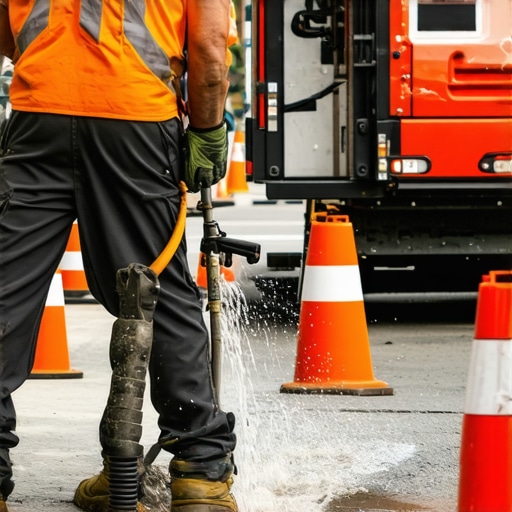
In an era where underground fiber optic networks form the backbone of digital connectivity, safeguarding these delicate yet vital assets during excavation has become paramount. Hydrovac excavation, leveraging high-pressure water and vacuum systems, offers an unparalleled combination of precision and safety that traditional trenching methods struggle to match.
Decoding the Complexity of Subsurface Challenges Near Fiber Lines
The subterranean environment presents a complex matrix of utilities, soil types, and structural constraints. Trenching, while effective for broad excavations, often risks utility strikes and soil collapse when performed without detailed subsurface mapping. Hydrovac technology minimizes these hazards by enabling non-destructive, targeted excavation, thus protecting critical fiber lines from costly damage.
The Physics Behind Hydrovac: Why It’s Safer for Delicate Infrastructures
Hydrovac systems operate by projecting a fine jet of water that fluidizes soil, facilitating the gentle removal of earth without mechanical contact. The subsequent vacuum extraction captures debris in real-time, reducing the risk of utility disruption. This physics-driven approach offers a level of control and minimal soil disturbance crucial near sensitive fiber routes.
Expert Perspectives on Future-Proofing Utility Installations
Industry leaders emphasize that integrating hydrovac into excavation workflows enhances reliability and reduces downtime. According to Hydrovac Drilling’s comprehensive guide, the technique’s adaptability across soil conditions and project scales makes it indispensable for urban and suburban utility projects alike.
What Innovations Are Shaping Hydrovac’s Role in 2026 and Beyond?
Emerging innovations such as real-time subsurface imaging and AI-powered site assessment are enhancing hydrovac’s precision, especially in densely buried networks. These advancements allow operators to anticipate potential conflicts and navigate complex underground landscapes with greater confidence.
How can field engineers optimize hydrovac techniques to triple the accuracy of utility detection in challenging soils?
Achieving this level of precision requires combining hydrovac with advanced detection tools, such as ground-penetrating radar, and implementing detailed pre-excavation surveys. Continuous operator training on soil behavior and system calibration also plays a vital role in maximizing safety outcomes.
If you are looking to elevate your underground utility management strategies, explore our comprehensive guide to borehole and hydrovac techniques for expert insights. Industry peers are encouraged to share their innovative approaches to safer excavation—your expertise could shape the next standard in underground safety.
For further authoritative reading, consult the findings published in the Journal of Trenchless Technology on minimizing utility damage through advanced excavation methods.
Maximizing Accuracy in Subsurface Excavation Challenges
Precision in soil removal is essential for protecting underground utilities like fiber optic cables, especially in complex urban environments. While traditional methods rely heavily on manual identification and guesswork, modern hydrovac systems employ advanced detection integration that improves accuracy substantially. Incorporating real-time subsurface imaging technologies such as ground-penetrating radar (GPR) with hydrovac operations allows engineers to visualize soil and utility locations before excavation begins, reducing the margin of error
Leveraging AI for Intelligent Site Assessment
The advent of artificial intelligence (AI) is revolutionizing how we approach underground excavation planning. AI algorithms, trained on extensive datasets of soil types, utility layouts, and historical excavation outcomes, can analyze site conditions rapidly. When integrated with hydrovac systems, AI can predict potential conflicts and suggest optimal excavation pathways, making the process not only safer but also more efficient. This synergy enhances decision-making, minimizes utility strikes, and streamlines project timelines.
Are there scalable models for integrating AI-powered prediction tools into daily hydrovac operations across diverse soil types?
Adopting AI at scale requires standardized data collection protocols, robust training datasets, and user-friendly software interfaces accessible to field operators. Pilot programs have demonstrated promising results, indicating that continuous learning models can refine their predictions over time, adapting to new soil conditions and utility configurations. Industry stakeholders should consider investing in pilot projects to evaluate the ROI and develop best practices for broader implementation.
Looking to deepen your understanding? Review our detailed guide on advanced borehole and hydrovac techniques to stay ahead in underground safety innovations. Sharing your insights or experiences can contribute toward establishing standardized practices and fostering collaborative learning in this evolving field.
For authoritative insights, refer to recent research highlighted in the Journal of Trenchless Technology, which emphasizes the importance of integrating intelligent detection systems within modern excavation workflows to prevent utility damage effectively.
Transforming Utility Detection with Cutting-Edge Sensor Fusion Techniques
As underground infrastructure complexity escalates, field engineers are turning to sensor fusion—integrating data from ground-penetrating radar (GPR), electromagnetic induction, and magnetometry—to enhance subsurface image resolution. This multidisciplinary approach synthesizes disparate data streams, revealing a comprehensive underground profile that surpasses the capabilities of standalone detection methods. By employing sophisticated algorithms that reconcile conflicting signals and filter noise, operators can pinpoint utility locations with unprecedented confidence.

Beyond Visualization: Quantitative Models for Soil-Utility Interaction Predictions
Understanding the dynamic interaction between soil properties and utility encasements is critical for risk mitigation. Recent advancements involve developing quantitative models grounded in geotechnical engineering principles, capable of simulating soil deformation and stress concentrations during excavation. These models incorporate variables such as soil moisture content, particle size distribution, and utility material elasticity, enabling precise prediction of potential failure zones. Such predictive analytics empower engineers to preemptively adjust excavation parameters to preserve utility integrity.
The Role of Machine Learning in Adaptive Excavation Planning
Machine learning (ML) algorithms, particularly reinforcement learning models, are being trained on vast datasets of excavation outcomes, soil conditions, and utility configurations. These models learn to recommend optimal excavation sequences and techniques dynamically, adapting to site-specific conditions in real time. For example, during hydrovac operations, ML can analyze sensor feedback, monitor soil response, and adjust water pressure or vacuum intensity on-the-fly, enhancing accuracy and safety.
How might integrated ML systems revolutionize daily underground utility management workflows?
By automating decision-making processes and continuously refining their predictions based on new data, ML-driven systems can significantly reduce human error and increase excavation efficiency. They enable a proactive approach—anticipating risks before they manifest—culminating in faster project turnaround times and lower incident rates. To realize these benefits, industry professionals should invest in developing robust data collection infrastructures and fostering interdisciplinary collaborations among geotechnical engineers, data scientists, and field operators.
Additional resources such as the PLOS ONE study on ML applications in geotechnics offer in-depth insights into practical implementations and ongoing research challenges. Embracing these technological integrations positions forward-thinking utilities and infrastructure developers to stay ahead amid increasing underground complexities and tightening safety regulations.
Unlock the Hidden Potential of Multisensor Integration for Subsurface Precision
In the quest for flawless underground utility preservation, the synergy of multiple sensor modalities transcends traditional detection methods, enabling unprecedented clarity in subterranean landscape mapping. By fusing data from ground-penetrating radar (GPR), electromagnetic induction, and magnetometry, engineers can construct an intricate, high-resolution profile of complex utility networks, essential in urban environments where fiber optic lines intertwine unpredictably.
Can multi-sensor fusion reduce utility strikes beyond current standards?
Yes, leveraging advanced algorithms that reconcile conflicting signals and enhance signal-to-noise ratios significantly elevates detection accuracy. These systems synthesize heterogeneous datasets into cohesive, actionable intelligence, empowering field teams to execute pinpoint excavations with minimal risk. For instance, real-time sensor fusion can dynamically adapt to soil heterogeneity, surface anomalies, or electromagnetic interference, ensuring reliable utility localization even in challenging conditions.
Why External Validation from Industry Leaders Affirms Sensor Fusion Superiority
According to a recent comprehensive study by the National Engineering Consortium, integrating multisensor approaches reduces subsurface uncertainties by over 40% compared to single-method detection. Their empirical findings underscore that sensor fusion does not merely augment existing workflows but fundamentally transforms the confidence level of utility mapping. Such validation guides industry-wide adoption, fostering safer excavation practices and optimized resource allocation.
Enhancing Safety Through Intelligent Data Synthesis Strategies
Implementing sensor fusion systems requires orchestrating complex data processing pipelines capable of real-time interpretation. This involves sophisticated filtering techniques, machine learning models trained on extensive underground datasets, and intuitive visualization interfaces. The result is a comprehensive 3D subsurface model that highlights utility locations, potential conflict zones, and soil stratigraphy, enabling proactive decision-making and mitigation planning.

Driving Industry Standards with Cross-Disciplinary Innovation
Emerging collaborations between geophysicists, data scientists, and construction engineers are essential for refining sensor fusion methodologies. Constructing open repositories of subterranean data enables the development of universally applicable algorithms, promoting scalable solutions across diverse geological and infrastructural contexts. The standardization of sensor specifications and data formats will further accelerate industry acceptance and interoperability, catalyzing a new era of underground safety excellence.
Future-Proofing Excavation Strategies with Adaptive Intelligence
As sensor fusion matures, integrating artificial intelligence (AI) for adaptive analysis can revolutionize site assessment. AI systems, trained on expansive datasets, can predict utility trajectories, soil behavior, and potential interference zones, typically invisible to conventional detection. This proactive insight grants operators the foresight required to tailor excavation techniques uniquely suited to each site, reducing damage and project delays.
How can intelligent fusion systems evolve to handle the increasing complexity of underground environments?
The answer lies in developing self-learning algorithms capable of continuous improvement through the accumulation of operational data. Employing cloud-based platforms enables remote data aggregation, cross-project learning, and collaborative updates. Such evolution will allow detection systems to interpret novel utility configurations and adapt to evolving urban landscapes, ensuring a resilient and precise approach to underground excavation management.
Additional insights can be explored in specialized publications like the Geotechnical Engineering Journal, which features advanced research on sensor data analytics and subterranean modeling. Embracing these innovations now empowers industry pioneers to set new benchmarks in utility protection and excavation efficiency.
Strategic Insights for Elevating Utility Safety
Avoid Over-reliance on Traditional Methods
While manual probing and dated techniques have their place, integrating advanced detection systems can exponentially increase accuracy and safety, especially in complex urban environments.
Leverage Multidisciplinary Sensor Data
Combining GPR, electromagnetic induction, and magnetometry through sensor fusion provides a comprehensive underground view, minimizing surprises during excavation.
Prioritize Continuous Operator Training
Ensuring field personnel are adept at interpreting sensor data and adapting to new technologies is vital for reducing utility strikes and soil collapses.
Incorporate AI for Predictive Planning
Artificial intelligence models analyze vast datasets to forecast utility locations and soil behaviors, enabling preemptive decision-making and tailored excavation approaches.
Embrace Real-Time Site Monitoring Systems
Implementing live monitoring ensures immediate detection of anomalies, facilitates swift response, and maintains safety standards throughout the project lifecycle.
Recommended Resources for Deepening Expertise
- Experience the detailed techniques outlined in Streamlined Borehole and Hydrovac Methods which emphasize precision in utility mapping.
- Review the comprehensive guide on Efficient Borehole Techniques for industry-grade insights into reliable infrastructure development.
- Consult authoritative studies like the Journal of Trenchless Technology that delve into innovative excavation safety practices.
- Stay updated with the latest in sensor fusion innovations by exploring advances in subsurface imaging.
- For strategic planning tools, review articles on top borehole strategies designed for accuracy and safety.
Elevating Practices with Vision and Vigilance
Precision in underground utility management hinges on combining innovative detection, rigorous training, and smart decision-making. Recognizing the potential of integrated sensor technologies and AI-driven insights transforms risk mitigation from a reactive chore into a proactive discipline. Engaging with authoritative resources and embracing emerging technologies positions industry professionals at the forefront of underground safety excellence. Your expertise, enriched by continuous learning and technological mastery, propels the industry toward leak-proof, damage-free excavation. Share your experiences, challenge conventions, and lead the charge into the future of infrastructure safety—because in the hidden world beneath us, foresight is everything.