
Stop Utility Damage: 5 Vacuum Excavation Tactics for 2026
Revolutionizing Subsurface Work: The New Frontier in Utility Damage Prevention
As underground infrastructure becomes increasingly intricate, the necessity for precise, reliable techniques in borehole and hydrovac excavation has never been more critical. Industry experts recognize that the integration of cutting-edge vacuum excavation and trenching methodologies is pivotal in mitigating risks associated with utility damage, thereby safeguarding critical assets and enhancing project efficiency.
Distinguishing Conventional from Next-Generation Excavation Techniques
Traditional trenching and excavation approaches often grappled with limited accuracy and safety concerns, especially in complex soil conditions. Today, innovations such as streamlined hydrovac and borehole drilling techniques allow for minimally invasive, highly targeted interventions. These advancements leverage sophisticated sensing technology and improved material handling, reducing the likelihood of inadvertent utility strikes.
Implementing High-Precision Utility Mapping to Foresee Challenges
Before any destructive activity, comprehensive subsurface utility mapping is essential. Techniques outlined in articles like Top Techniques for Precise Utility Mapping exemplify the importance of integrating geophysical surveys with real-time data analysis. Such practices enable professionals to preemptively identify potential conflict zones, optimizing excavation strategies and preventing costly damages.
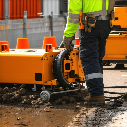
The Role of Vacuum Excavation in Modern Infrastructure Maintenance
Vacuum excavation, especially hydrovac systems, has emerged as a cornerstone in safe underground work. Their non-destructive nature permits visual confirmation of utility locations, dramatically reducing risk. The evolution of these techniques, including enhanced filtration systems and adaptive suction controls, has substantially improved the safety and reliability of site operations, as detailed in The Ultimate Guide to Safe Subsurface Work.
Expert Inquiry: How Can Industry Standardization Reduce Error Margins in Vacuum Excavation?
This pressing question echoes among specialists striving for consistency and safety. The development of industry-wide protocols, coupled with advanced training modules, aims to minimize variability across projects and operators. Such standardization enhances the predictability of outcomes, fostering a safer underground environment for all stakeholders.
Enhancing Safety Through Integrated Technologies
Incorporating IoT sensors, GIS mapping, and AI analytics into excavation workflows significantly elevates decision-making accuracy. These tools facilitate real-time monitoring and adaptive responses, aligning with the latest industry standards. For example, strategic deployment of these technologies aligns with recommendations found at Strategies for Reliable Infrastructure, promising fewer surprises underground.
Invitation to Share Insights and Advance Industry Practice
For professionals committed to refining underground work practices, engaging in forums and contributing experiential knowledge is invaluable. Your insights can catalyze further innovation in vacuum excavation and trenching, fostering a safer and more efficient future.
Harnessing Smart Technologies for Enhanced Underground Safety
Adopting emerging digital tools such as GIS-based mapping combined with AI-driven analytics offers a transformative impact on underground utility protection. These technologies enable real-time detection of potential conflicts, allowing crews to adjust excavation plans proactively. For instance, integrating comprehensive safety protocols with intelligent sensing systems can significantly reduce accidental utility strikes, boosting project reliability and safety standards.
What Are the Limitations of Current Utility Mapping Techniques?
Despite technological advancements, current utility mapping methods face challenges such as soil heterogeneity and equipment limitations. These factors can compromise the accuracy of geophysical surveys, especially in urban environments with complex underground networks. Recognizing these limitations is essential for developing hybrid approaches that combine traditional ground-penetrating radar with innovative borehole techniques, as discussed in latest mapping strategies.
How Can Industry Standardization Elevate Safety and Efficiency?
Implementing universally accepted standards for vacuum excavation and trenching practices can dramatically limit variability between projects. Standardized training aligned with these protocols ensures operators are equipped with best practices, fostering consistency. For a detailed framework, consult resources like industry best practices. Such standardization not only minimizes errors but also accelerates the adoption of innovative techniques across sectors.
We invite industry professionals to share their experiences with emerging technologies. Your insights can influence the development of next-generation safety protocols, further advancing the field of underground utility protection, as emphasized in recent industry analyses.
Elevating Detection Accuracy With Cutting-Edge Geophysical Technologies
Achieving pinpoint accuracy in subterranean utility detection hinges on the deployment of advanced geophysical tools such as electromagnetic induction and multi-frequency ground-penetrating radar (GPR). These technologies, when integrated with real-time data analytics, enable engineers to map underground networks with unprecedented clarity. For instance, recent developments feature adaptive algorithms that calibrate signal processing dynamically, accounting for soil variability and electromagnetic interference, thus improving detection reliability in complex urban settings.
Addressing the Urban Complexity: Overcoming Soil and Infrastructure Interactions
Urban environments pose unique challenges due to heterogeneous soil compositions, existing foundations, and dense utility corridors. These factors create a multilayered obstacle course for traditional detection methods. To navigate this, multidisciplinary approaches embracing geotechnical investigations, sensor fusion, and machine learning models are emerging as best practices. Implementing such hybrid strategies compensates for individual method limitations, enabling a cohesive interpretation of data that informs safer excavation planning.

Is There a Future for Automated Utility Mapping Systems?
The evolution toward automation in underground utility detection is accelerating. Autonomous mapping systems equipped with AI-driven image recognition, robotic sensors, and drone-based deployment could revolutionize field operations. These innovations promise reduced human error, faster project turnaround, and enhanced safety — a leap forward in the industry’s quest for precision. According to the latest industry white papers from the Geospatial World Association, integrating automation with existing workflows can substantially lower operational costs and improve detection fidelity.
How Will Industry Standardization Adapt to Rapid Technological Advances?
As detection technologies evolve, the establishment of adaptive industry standards becomes crucial. These standards must be flexible enough to incorporate emerging tools while maintaining rigorous safety benchmarks. Initiatives led by bodies such as the National Utility Detection Association (NUDA) are pioneering dynamic certification programs and best practices adaptable to innovations like AI and automation. This ensures that practitioners remain at the forefront of safety and efficiency, fostering trust among stakeholders and regulatory agencies alike.
Engagement from seasoned professionals in crafting these evolving standards will not only accelerate adoption but also embed a culture of continuous improvement. Your perspectives are invaluable. Consider participating in industry forums or contributing to guideline development — your expertise can shape the future landscape of underground utility safety and accuracy, as industry leaders are increasingly calling for collaborative innovation.
Embracing the Digital Revolution in Subsurface Exploration
The integration of cutting-edge digital tools is transforming underground utility detection, offering unprecedented precision and safety. Advanced GIS platforms fused with AI analytics enable operators to anticipate conflicts before excavation begins, shifting the paradigm from reactive to proactive management of subterranean environments.
Why Conventional Utility Mapping Cannot Keep Up with Urban Complexity
Traditional methods, such as surface geophysical surveys, often falter amid dense urban infrastructure. Soil heterogeneity, electromagnetic interference, and layered underground compositions demand more sophisticated solutions. Recognizing these limitations underscores the necessity for hybrid approaches combining ground-penetrating radar, electromagnetic induction, and borehole technologies. Industry reports, like those from the Geospatial World Association, highlight the critical need for adaptable, multi-modal detection strategies.
Can AI-Powered Systems Fully Replace Manual Surveys in Utility Mapping?
This is a question at the forefront of industry innovation. Emerging AI-driven autonomous detection platforms are demonstrating remarkable capabilities in real-time data processing and anomaly recognition. While promising, they currently supplement rather than wholly replace expert interpretation, ensuring a synergistic approach that leverages human insight with machine efficiency.

Unlocking Predictive Maintenance to Prevent Utility Failures
Predictive analytics derived from comprehensive subsurface data allow utilities to forecast potential stress points and failures proactively. By harnessing sensor networks coupled with historical maintenance data, operators can schedule interventions before issues manifest, significantly reducing emergency repairs and service disruptions.
The Frontiers of Thermal and Chemical Signal Detection
Beyond electromechanical methods, the exploration of thermal and chemical sensing technologies introduces new dimensions to utility detection. For instance, high-precision thermal cameras can identify underground pipelines through subtle heat signatures, while chemical sensors detect leakage or corrosion. These innovations, detailed in recent specialized studies, expand the toolbox for modern underground diagnostics.
What Role Will Quantum Sensing Play in Future Utility Discrimination?
Quantum sensing represents an emerging frontier, offering ultra-sensitive measurement capabilities capable of distinguishing between different underground materials with exceptional accuracy. Though still in experimental phases, quantum technologies promise to reduce false positives and enhance utility differentiation in complex underground landscapes, as evidenced by ongoing research in advanced sensor labs worldwide.
Expert Insights & Advanced Considerations
Harnessing Multimodal Detection Techniques
Combining ground-penetrating radar with electromagnetic induction enables a more comprehensive understanding of underground environments, reducing false positives and improving reliability in utility mapping.
The Impact of Automation on Safety and Precision
Automation, including robotic sensors and drone-assisted surveys, promises to enhance detection speed and accuracy, while minimizing human risk in complex excavation zones.
Overlaying Data for Better Decision-Making
Integrating GIS data with real-time sensor inputs creates dynamic models that support proactive planning, helping teams avoid utility strikes before they occur.
Standardizing Protocols to Reduce Variability
Developing universal standards and training programs ensures consistent application of best practices, leading to safer excavation outcomes across the industry.
Addressing Urban Complexity
Urban underground environments demand hybrid approaches—blending multiple sensing technologies and geotechnical insights—to navigate challenging soil and infrastructure interactions effectively.