
Hydrovac & Borehole Drilling: Top Strategies for Precise Utility Mapping 2025
Transforming Underground Utility Mapping: The Critical Role of Advanced Trenching and Vacuum Excavation in 2025
As infrastructure demands grow increasingly complex, the necessity for precision in underground utility detection intensifies. Techniques such as hydro excavation, vacuum excavation, and borehole drilling have evolved from simple methods to sophisticated strategies that prioritize safety, accuracy, and efficiency. In this landscape, understanding the nuanced interplay between these technologies is essential for professionals aiming to optimize their projects and mitigate risks associated with subterranean work.
Why Hydro Excavation Innovates in Utility Detection
Hydro excavation, often referred to as hydrovac, revolutionizes traditional trenching by providing non-destructive digging capabilities that significantly reduce the risks of damaging existing utilities. Its high-pressure water jets combined with powerful vacuum systems enable precise excavation in congested environments, making it indispensable for tasks requiring minimal surface disruption. For example, expert applications in urban utility mapping leverage hydrovac units to expose cables and pipes safely before construction activities commence, minimizing costly accidents and project delays. Furthermore, the integration of real-time imaging and GPS positioning elevates hydro excavation’s reliability, aligning with the latest standards outlined in industry white papers.
The Strategic Advantage of Borehole Excavation for Detailed Subsurface Profiling
Borehole techniques serve as complementary tools to hydrovac operations, offering targeted subsurface data crucial for master planning and risk assessment. Strategic borehole placement can uncover geological anomalies, pipeline depths, and soil conditions, providing a comprehensive understanding of underground environments. In 2025, innovations such as rotary core drilling and advanced geophysical sensors enable rapid data acquisition with minimal surface impact, enhancing accuracy in utility mapping and infrastructure resilience. These methods are particularly valuable in balancing the need for detailed information and compliance with environmental regulations.
Addressing Complex Queries: Is Vacuum Excavation Sufficient for Deep Utility Detection?
Given the limitations of traditional vacuum excavation, how effective are these techniques in uncovering utilities at greater depths?
While vacuum excavation excels in shallow to moderate depth applications, its efficacy diminishes with increasing depth due to equipment limitations and soil variability. To augment depth detection, advanced borehole drilling becomes necessary, integrating geophysical techniques to locate utilities beyond conventional reach. An industry study published in the Journal of Geotechnical and Geoenvironmental Engineering emphasizes the importance of combining shallow vacuum methods with targeted borehole investigations for comprehensive utility detection.
If you seek to refine your underground mapping strategies, exploring recent case studies and technological advancements can provide actionable insights. Consider consulting resources such as the latest expert guides on hydrovac applications to stay ahead of the curve. Share your experiences and insights with professional forums to contribute to collective knowledge and elevate safety standards across the industry.
Considering these developments, continuous investment in integrated underground detection systems not only enhances project accuracy but also aligns safety protocols with the highest standards established by industry leaders.
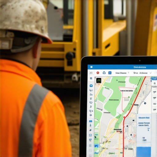
Embracing Digital Innovation for Precise Utility Mapping
As the underground utility landscape becomes increasingly intricate, reliance on traditional detection methods may fall short in meeting contemporary requirements. Integration of digital technologies, such as 3D GIS mapping and drone-assisted surveys, revolutionizes the way professionals approach subsurface exploration. Combining these innovations with hydro excavation techniques enhances spatial accuracy and provides a comprehensive picture of underground conditions. For example, utilizing geospatial analytics alongside hydrovac data allows for more informed decision-making, reducing risks associated with unforeseen utility conflicts. Industry experts advocate for adopting these digital tools early, aligning with best practices outlined in recent industry white papers.
How Can Combining Borehole and Trenching Techniques Elevate Project Safety?
Blending targeted borehole investigations with trenching operations creates a multi-layered approach to underground detection. Boreholes focus on specific areas requiring detailed analysis, revealing soil composition, utility depth, and geological features that trenching alone might miss. This combined strategy minimizes surface disruption while providing critical insights, particularly in complex urban environments. Recent advancements in directional drilling and geophysical sensors enable fast, minimally invasive borehole explorations, ensuring project timelines stay on track without compromising safety. Developing integrated plans that leverage both methods can result in more reliable infrastructure installation, as discussed in expert guides available on industry-leading platforms.

Challenging Assumptions: Is Every Excavation Method Suitable for All Projects?
While hydro excavation and borehole techniques are versatile, their suitability varies depending on project scale, depth requirements, and environmental constraints. Overgeneralizing these methods can lead to safety oversights or inefficiencies. For instance, shallow vacuum excavation is optimal for quick utility location in urban settings, but it may not suffice for deep underground structures. Conversely, extensive borehole investigations, though more accurate, involve higher costs and longer timelines. Recognizing the unique contours of each project and adopting a tailored combination of methods—such as those discussed in expert strategies for reliable infrastructure—is fundamental for success. Professionals are encouraged to develop dynamic workflows that adapt to project complexity, ensuring both safety and efficiency are maximized.
Want to delve deeper into innovative underground detection techniques? Explore comprehensive case studies and the latest technological breakthroughs to stay at the forefront of industry standards and safety protocols.
Revolutionizing Subsurface Exploration with Multi-Modal Data Integration
In the quest for unparalleled accuracy in underground utility detection, engineers and geoscientists are increasingly turning towards integrated data systems that synthesize information from diverse sources. By harmonizing borehole core sampling, geophysical surveys, and real-time geospatial analytics, teams can develop high-fidelity models of subterranean environments. This multi-modal approach enhances the precision of utility location, mitigates risk during excavation, and conserves resources by reducing unnecessary drilling. For example, advanced algorithms now enable the fusion of resistivity measurements with seismic velocity data, creating cohesive 3D models that inform decision-making with an unprecedented level of detail.
How does combining geophysical surveys with borehole data transform utility mapping accuracy?
Combining geophysical survey techniques such as ground-penetrating radar (GPR), electromagnetic induction, and seismic refraction with direct borehole data creates a layered understanding of the subsurface. This synergy allows for cross-verification of findings, identification of anomalies, and prediction of utility locations with higher confidence. The integration employs sophisticated data analytics platforms capable of handling large datasets, applying machine learning to recognize patterns, and generating actionable insights. As a result, project teams can preempt utility conflicts and streamline excavation workflows, aligning with industry directives outlined in recent authoritative reports by the National Association of Utility Locators.
To stay ahead in this rapidly evolving field, professionals should explore courses on geophysical data fusion and participate in industry forums where case studies demonstrate successful integration strategies. The use of digital twins—virtual replicas of the underground environment—has also emerged as a transformative tool, enabling simulation of excavation impacts and preplanning of safe digging zones, which are crucial in densely built urban landscapes. Embracing these technologies not only boosts safety but significantly enhances project efficiency, leading to cost savings and reduced environmental footprint.
Advancing Borehole Drilling with Smart, Sustainable Solutions
Contemporary borehole drilling is redefining what is possible through the adoption of smart drilling systems equipped with AI-driven sensors and environmentally conscious methodologies. These innovations facilitate precise control of drill bit orientation, real-time soil analysis, and adaptive navigation through complex soil matrices. Moreover, sustainable drilling practices, such as using biodegradable lubricants and recycling drilling fluids, minimize ecological disturbance. An example includes the deployment of automated core sampling rigs that adjust drilling parameters dynamically, resulting in cleaner boreholes and higher data quality.
What benefits does AI integration bring to deep underground utility detection and environmental safety?
The integration of artificial intelligence into borehole operations revolutionizes both detection capabilities and environmental management. AI algorithms analyze continuous streams of data gathered during drilling, predicting potential utility encounters before physical contact occurs. This preemptive insight allows operators to modify drilling trajectories proactively, avoiding utility strikes and environmental hazards. Furthermore, AI assists in anomaly detection, soil characterization, and predictive maintenance of drilling equipment, enhancing operational safety and reducing downtime. Industry research underscores that such intelligent systems contribute to a safer, more sustainable excavation process, particularly in sensitive urban or ecologically fragile regions.
Professionals aiming to implement AI-enhanced borehole techniques should consider collaborating with data scientists and leveraging emerging frameworks like digital twins and IoT-enabled sensor networks. These integrations empower teams with actionable insights, fostering a proactive safety culture and optimizing resource deployment. As technology progresses, adopting these advanced systems becomes an essential component of comprehensive underground utility management, paving the way for a future where subterranean exploration is more precise, safe, and environmentally responsible.
#{imagePrompt:
Unveiling the Future: How Integrated Data Revolutionizes Underground Detection
As urban infrastructures grow denser and subterranean environments more complex, the necessity for multidimensional data integration becomes essential. The fusion of geophysical survey data with advanced borehole analytics has unlocked new frontiers in utility detection accuracy. By leveraging machine learning algorithms that synthesize electrical resistivity, seismic wave velocity, and direct sampling results, engineers can generate comprehensive 3D underground models. This convergence minimizes uncertainty, prevents utility strikes, and optimizes resource deployment, embodying the next evolution in subterranean mapping that industry leaders are rapidly adopting.
Expert Insights: How Can Smart Drilling Technologies Elevate Safety and Sustainability?
Implementing AI-powered drilling rigs and eco-conscious practices transforms core aspects of underground exploration. Smart systems provide real-time soil condition monitoring, adapting drilling parameters dynamically to prevent utility damage while reducing environmental impact. For example, biodegradable drilling fluids combined with automated core sampling not only preserve ecological integrity but also enhance data fidelity. The integration accelerates project timelines and adheres to strict environmental regulations, making it indispensable for complex urban projects seeking both precision and sustainability.
Best Practices for Tailoring Techniques to Project Nuances
Customizing the blend of trenching, vacuum excavation, and borehole methods hinges on a comprehensive assessment of site-specific factors. For densely populated zones with shallow utilities, high-precision hydrovac operations complemented by targeted boreholes efficiently balance safety and cost. Conversely, regions with deeper infrastructure demands innovative deep-drilling solutions integrated with real-time geophysical sensing. Adopting a modular approach, guided by the latest technological breakthroughs published by institutions like the American Society of Civil Engineers, ensures project adaptability and optimal outcomes.
What Are the Hidden Pitfalls of Over-Reliance on a Single Technique?
Can dependence on standalone methods compromise underground safety and project efficiency?
Exclusively relying on a singular detection approach often leads to critical blind spots, especially in unpredictable geological contexts. For example, shallow vacuum excavation might fail to detect deeply embedded utilities or geological anomalies, risking costly strikes and project delays. Similarly, exclusive use of geophysical surveys without verification through boreholes can produce ambiguous results. Balancing multiple modalities—each with inherent strengths—fosters redundancy, cross-verification, and greater confidence. Industry-specific studies, such as those from the U.S. Geological Survey, underscore that integrated strategies significantly reduce risk profiles and improve decision-making precision.
If your objective is to exemplify industry-leading safety with next-gen technological synergies, engaging with specialized training and continuous data analysis remains pivotal. Explore expert webinars and case studies to deepen your operational acumen and stay ahead of evolving standards.
Advancing the Underground Landscape with Digital Twins and Real-Time Analytics
Digital twin technology embodies the pinnacle of predictive underground modeling, allowing teams to simulate excavation scenarios, utility conflicts, and environmental impacts before physical work begins. Coupled with real-time sensor networks embedded within boreholes, these virtual replicas provide instant feedback, enabling proactive adjustments and safeguarding critical infrastructure. The application of augmented reality overlays further enhances on-site decision-making, reducing errors and accelerating project timelines. Leading industry publications, such as the International Journal of Digital Construction, highlight how this convergence elevates safety protocols and operational efficiency in complex subterranean environments.
Expert Insights & Advanced Considerations
The Fusion of Data Streams Enhances Accuracy
Integrating geophysical survey data with direct borehole sampling creates a comprehensive underground profile, significantly reducing utility strike risks and enabling precise infrastructure planning.
AI-Driven Drilling Elevates Safety Standards
The deployment of artificial intelligence in borehole operations allows for real-time soil analysis and predictive modeling, leading to fewer utility damages and more sustainable project execution.
Tailoring Detection Strategies Adapts to Site Complexity
Customized approaches combining trenching, vacuum excavation, and borehole techniques ensure safety and efficiency, especially in urban environments with dense underground networks.
Digital Twins Transform Pre-Construction Scouting
Virtual underground replicas facilitate simulation of excavation scenarios, helping teams identify potential conflicts before physical work begins.
Embracing Digital Innovation Outpaces Traditional Methods
Adoption of 3D GIS, drone surveys, and geospatial analytics offers a multi-dimensional view, enhancing decision-making and project safety in complex subterranean landscapes.
Curated Expert Resources
- Hydrovac Trenching Expertise for Safer Underground Projects: Provides foundational knowledge on integrating hydro excavation into utility detection, emphasizing safety and precision.
- Advanced Strategies for Vacuum Excavation: Offers insights on optimizing vacuum methods for complex environments.
- Innovative Borehole Drilling Techniques: Focuses on latest advancements in borehole technology, including geophysical sensors and AI integration.
Final Perspective: Leading the Charge into 2025
By synthesizing cutting-edge data integration, AI advancements, and customized detection tactics, industry professionals are transforming underground utility mapping into a safer, more accurate discipline. Embracing these innovations not only minimizes risks but sets new standards for efficiency in complex subterranean projects. Explore these resource-rich guidelines and technological breakthroughs—your pathway to leading-edge expertise—by engaging with industry forums or consulting advanced case studies. Staying ahead means continuously refining your approach, integrating emerging tools, and sharing insights to elevate safety and precision in underground infrastructure development.