
Borehole Drilling Techniques for Accurate Utility Mapping in 2025
Harnessing Cutting-Edge Trenching Technologies for Future-Ready Utility Mapping
As urban infrastructure growth accelerates, the demand for highly accurate and minimally invasive underground utility detection has become paramount. Trenching, borehole, hydrovac, and vacuum excavation methodologies have undergone transformative advancements, enabling engineers to achieve unprecedented precision in subterranean mapping. In 2025, leveraging these innovative techniques ensures optimized project outcomes, reduced risks, and compliance with stringent safety standards.
Integrating Hydrovac and Vacuum Excavation for Optimal Subsurface Investigations
Hydrovac excavation has revolutionized traditional trenching by utilizing high-pressure water streams combined with vacuum systems to expose underground utilities without damaging surrounding structures. This technology minimizes soil disturbance and enhances accuracy during utility detection. The reliability of hydrovac vacuum excavation solutions underscores their vital role in complex urban environments, especially when delicate infrastructure such as fiber optics or gas lines is involved.
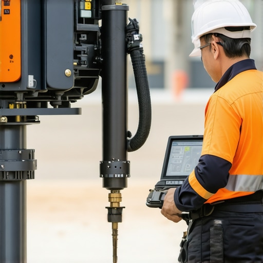
Emerging Trends in Borehole Drilling for Utility Data Collection
Advanced borehole strategies in 2025 focus on precision drilling complemented by real-time subsurface imaging technologies. These methods improve data fidelity for geographic information systems (GIS) integration, allowing infrastructure planners to overlay existing maps with high-resolution underground data. This synergy between drilling and digital mapping facilitates proactive maintenance and asset management.
How Do Innovative Techniques Mitigate Risks Associated with Utility Interference?
Traditional trenching often encounters unforeseen obstacles like unmarked pipelines or undocumented cables, which can lead to costly delays and safety hazards. Advanced vacuum excavation and trenching methods now incorporate ground-penetrating radar (GPR) and electromagnetic detection systems. These tools identify underground utilities before physical disruption, significantly reducing environmental impact and enhancing occupational safety, a practice supported by research in infrastructure risk mitigation.
What Are the Latest Innovations Addressing Complex Urban Utility Networks?
Urban environments pose unique challenges due to densely packed, overlapping utilities. Innovations such as streamlined hydrovac borehole techniques incorporate automated guidance systems and portable diagnostic sensors to navigate through complex subterranean landscapes. These advancements not only improve mapping accuracy but also enable faster project turnaround times.
Industry leaders and technical experts continuously refine these methods, emphasizing safety and environmental stewardship. For those involved in underground infrastructure projects, understanding and deploying these advanced techniques are critical to maintaining project integrity and community trust.
To deepen your insights, explore resources like the comprehensive latest borehole and hydrovac methods, or contribute your professional experiences to ongoing dialogues in underground utility detection innovations. Accurate underground mapping is no longer a mere option; it is an essential component of modern infrastructure development, driven by technological convergence and expert-driven practices.
Enhancing Accuracy Through Integrated Geophysical Surveys
One of the pivotal advancements in underground utility detection involves combining borehole methods with sophisticated geophysical surveys such as ground-penetrating radar (GPR) and electromagnetic induction. These integrated approaches enable engineers to identify utility lines and anomalies with unparalleled precision, reducing the risk of accidental strikes. Leveraging such combined techniques can significantly improve data reliability, especially in complex urban settings where multiple utilities overlap.
Customizing Borehole Strategies for Complex Environments
Every project demands a tailored approach, considering factors such as soil composition, existing infrastructure, and environmental constraints. Recent developments focus on adaptive borehole techniques that adjust drilling parameters in real-time, optimizing performance across diverse geologies. For instance, variable-density drilling fluids help navigate unstable soils, while advanced telemetry systems transmit data wirelessly for immediate analysis, streamlining decision-making processes.
Addressing Subsurface Private Property and Heritage Areas
When exploring underground layers beneath private properties or heritage sites, sensitivity and precision are paramount. Emerging methods incorporate non-invasive borehole drilling combined with remote sensing technologies, minimizing surface disturbance. Additionally, digital twin models—virtual replicas of subsurface conditions—allow for careful planning and risk assessment before any physical intervention, aligning with best practices recommended by authorities like the Heritage Preservation Society.
How can predictive analytics and machine learning further optimize borehole drilling efficiency and safety?
By harnessing predictive analytics and machine learning algorithms trained on extensive geological datasets, industry professionals can forecast subsurface conditions with greater certainty. These tools facilitate proactive risk mitigation, reduce unexpected terrain challenges, and enhance overall project timelines. Integrating such AI-driven solutions with existing borehole strategies is increasingly becoming a standard for forward-thinking infrastructure projects, as noted in recent research published by the Infrastructure Analytics Consortium.
Want to stay at the forefront of underground exploration? Sharing your experiences or exploring case studies on innovative borehole techniques can offer invaluable insights. Join industry forums or webinars to collaborate on evolving best practices, ensuring your projects benefit from the latest technological breakthroughs.
Unlocking Predictive Power with Artificial Intelligence in Underground Surveys
Harnessing the synergy between **predictive analytics** and **machine learning** unlocks new horizons in underground utility detection. By analyzing vast datasets from previous projects, subsurface conditions, soil behaviors, and utility layouts, AI algorithms can forecast potential hazards and areas prone to interference. This proactive approach not only minimizes risk but optimizes resource allocation, ensuring that excavation teams are prepared for complex underground environments.
Can AI anticipate and adapt to subterranean surprises before excavation begins?
Absolutely. Advanced AI systems utilize real-time data inputs from sensor arrays, remote sensing, and geophysical surveys to create dynamic models of the subsurface. These models evolve as new data flows in, offering engineers anticipatory guidance that helps in planning excavations with minimal surprises. According to a study by the Infrastructure AI Institute, integrating machine learning with geospatial data reduces utility strikes by up to 35% in dense urban regions.
Digital Twins: Virtual Replicas Driving Safer and Smarter Excavations
The advent of digital twin technology has transformed underground mapping from static plans to living, interactive models. These virtual replicas incorporate real-time sensor data, geophysical survey results, and predictive analytics, offering a comprehensive view of the underground landscape. In complex projects involving heritage sites or private properties, digital twins serve as invaluable planning tools, allowing for simulation of various excavation scenarios, assessing potential impacts, and refining strategies before physical work commences.

Imagine a detailed digital twin model overlaying a dense urban area, illustrating utility lines, soil stratification, and construction zones, facilitating risk-free planning and decision-making.
What challenges must be addressed to fully integrate digital twins into routine underground utility projects?
While digital twins offer significant advantages, several hurdles remain. High-fidelity data collection requires sophisticated sensors and consistent updates, which can be resource-intensive. Ensuring data accuracy and interoperability among diverse systems and stakeholder platforms is also crucial. Moreover, developing standardized protocols for creating and maintaining these virtual models ensures reliability and widespread adoption. A report by the Smart Infrastructure Consortium emphasizes that overcoming these challenges hinges on industry-wide collaboration and investment in scalable, cloud-based platforms.
Engaging with innovative digital twin frameworks empowers project managers and engineers to preemptively identify conflicts, streamline workflows, and enhance safety margins. As technology evolves, ongoing research and cross-sector partnerships will be pivotal in cementing digital twins as a mainstay in underground utility management. Consider exploring partnerships with tech providers specializing in IoT integrations or participating in pilot programs that test these cutting-edge solutions in real-world scenarios. Ready to pioneer the future of underground infrastructure mapping? Join professional networks, attend industry conferences, and contribute to developing regional standards that facilitate broader adoption and innovation.
Next-Generation Techniques Transforming Subsurface Mapping
In the rapidly evolving landscape of underground utility detection, emerging methodologies harness the power of multi-sensor fusion, real-time data analytics, and robotics to enhance accuracy and safety. Cutting-edge trenching methods integrate autonomous systems with geophysical surveys, allowing for preemptive obstacle identification and dynamic path planning. As urban environments become more congested, these innovations are essential for minimizing disruptions and safeguarding existing infrastructure.
Unveiling the Power of Hybrid Sensor Arrays in Complex Terrains
Hybrid sensor arrays combining electromagnetic induction, ground-penetrating radar, and acoustic sensors facilitate comprehensive subsurface characterization. This multi-modal approach reduces false positives and improves utility delineation, especially in heterogeneous soils or areas with overlapping services. Recent studies suggest that deploying portable sensor suites equipped with machine learning algorithms can adaptively filter noise and improve detection confidence in challenging conditions.
How Can Robotics Elevate Site Safety and Precision During Excavation?
Robotic systems equipped with advanced sensing and navigation capabilities enable remote operation in hazardous zones, reducing human exposure to risks. These machines can perform precise trenching and utility exposure, guided by real-time imaging and AI-driven analysis. Incorporating such systems not only accelerates project timelines but also minimizes surface disturbance and potential utility strikes, aligning with industry safety standards.
Are developments in subterranean mapping reshaping regulatory compliance?
Absolutely. Regulators increasingly recognize the importance of comprehensive subsurface data, prompting revisions in safety codes and permitting processes. Technologies that deliver high-fidelity, audit-ready data facilitate compliance verification and liability mitigation. Leading authorities like the National Infrastructure Safety Authority advocate for adopting integrated geophysical and digital twin solutions as standard practices in urban planning and construction.
Engage with these advancements by exploring collaborative opportunities with research institutions or tech developers. Sharing insights and field data accelerates the refinement of detection algorithms and fosters industry-wide adoption of best practices, ensuring that underground mapping keeps pace with urban expansion.
Augmenting Detection with Deep Learning Models
Deep learning models trained on extensive underground utility datasets are capable of predicting probable locations of undocumented pipes and cables. These predictive models enable engineers to prioritize inspection zones and plan excavation strategies more effectively. Integrating AI with sensor data streams creates a proactive approach, shifting the paradigm from reactive mitigation to anticipatory safeguards.
Spearheading Sustainability through Non-Invasive Techniques
Environmental considerations drive innovations toward non-invasive or minimally invasive detection methods. Techniques such as electromagnetic tomography and borehole-based resistivity measurements minimize soil disruption and preserve surface stability. Supporting this, the development of eco-friendly sensors and energy-efficient operation protocols aligns with sustainability goals, reinforcing responsible infrastructure development.
What are the key challenges in adopting AI-driven subterranean diagnostics at scale?
Scaling AI solutions faces hurdles including data quality assurance, integration with legacy systems, and the need for high computational resources. Establishing standardized data formats and fostering industry collaboration are critical steps toward widespread implementation. Research by the AI Infrastructure Alliance highlights the importance of interoperable platforms and open data sharing to accelerate AI adoption in underground utility management.
Consider contributing to these transformative efforts by participating in pilot projects or professional forums that explore AI innovations. Your expertise can shape the future of subterranean detection, making urban development safer, more precise, and sustainable.
Expert Insights & Advanced Considerations
Maximize Data Accuracy with Multi-Modal Sensing
Leveraging hybrid sensor arrays that combine electromagnetic induction, ground-penetrating radar, and acoustic methods allows for comprehensive subsurface profiling, significantly reducing false positives and enhancing reliability in utility detection.
Implement Real-Time Decision Support to Avoid Surprises
Integrating real-time geophysical data with adaptive drilling systems empowers operators to dynamically adjust strategies, minimizing risks associated with complex underground environments and overlapping utilities.
Prioritize Digital Twins for Complex Projects
Developing accurate virtual replicas of subsurface conditions—digital twins—enables detailed scenario analysis, risk assessment, and informed decision-making before physical excavation begins, especially in sensitive or heritage-rich sites.
Enhance Surface Preservation Through Non-Invasive Methods
Employing advanced non-invasive techniques such as electromagnetic tomography and resistivity measurements reduces surface disruption, supports environmental sustainability, and maintains urban aesthetics during subsurface investigations.
Harness AI for Predictive Subsurface Modeling
Applying machine learning algorithms trained on extensive geological and utility datasets enables the anticipation of undocumented utilities and geological anomalies, leading to proactive safety measures and efficient project planning.
Curated Expert Resources
- Top Borehole and Hydrovac Techniques for Precise Underground Infrastructure in 2025 – Offers comprehensive insights into the latest advancements in borehole and hydrovac methods, essential for high-accuracy utility mapping.
- Hydrovac Vacuum Excavation Reliable Solutions for Safe Construction Sites – Details state-of-the-art vacuum excavation strategies that ensure safety and precision in complex urban settings.
- Effective Trenching and Borehole Strategies for Reliable Infrastructure Today – Focuses on practical approaches and technological integration for modern underground utility detection.
- Predictive Analytics and Machine Learning in Subsurface Surveys – Explores AI-driven innovations that forecast underground conditions, reducing surprises and optimizing resource allocation.
The Final Word from the Experts
Advancements in trenching, borehole, hydrovac, and vacuum excavation technologies are fundamentally reshaping underground utility mapping. Embracing these innovations not only minimizes risk and environmental impact but also elevates project precision and safety. To stay at the forefront, professionals must continuously integrate emerging tools like digital twins and AI-driven predictive models, ensuring infrastructure development remains efficient, sustainable, and adaptive. Engage with industry peers, contribute your expertise, and explore pioneering resources to lead the next wave of underground exploration excellence.